![[Translate to English:]](/media/_processed_/9/2/csm_Allgemein_Thueringen_Hainich_Mischwald_Bolte_2__19d9dab56a.jpg "[Translate to English:]")
![[Translate to English:]](/media/_processed_/d/2/csm_100_0001_0013_c05c63e7db.jpg "[Translate to English:]")
Project
Regionalization WZE
Regionalization of the Crown Condition Survey
Forest trees at very different sites in Germany are increasingly suffering from climate change. In this project, the cause-effect relationships between environmental influences and tree vitality are to be investigated in order to generate country-wide maps based on the sample points of the Crown Condition Survey (Waldzustandserhebung WZE).
Background and Objective
The WZE annually records the vitality status of forest trees. Since 1984, the data collection has been carried out nationwide on a representative sampling network (Level I monitoring) and allows the evaluation of crown defoliation (needle/leaf loss) and tree mortality at the federal and state level for the most important tree species in Germany. Due to the increasing stress on forests caused by climate change, wall-to-wall maps of these parameters are needed, which can be used to make statements about individual regions and forest stands, even between sample points. In this project, the statistical correlations between a wide range of environmental influences and tree vitality will be investigated using WZE data. These correlations can then be used to derive predictions for all forest sites in Germany.
Approach
Wall-to-wall maps are available for many different environmental variables, all of which could have an influence on tree vitality. First of all, these are the topography and soil properties. Furthermore, weather and especially deviations from the long-term climate mean (e.g. droughts) are considered. Various remote sensing techniques provide information on forest structure, species composition, and disturbance events. All these factors are examined for their influences with regard to vitality using the long time series of the WZE. For this purpose, methods from the fields of machine learning and geostatistics are used, which can then be used to create maps for the whole of Germany.
Thünen-Contact

Involved Thünen-Partners
Funding Body
-
Federal Ministry of Food und Agriculture (BMEL)
(national, öffentlich)
Duration
7.2021 - 4.2025
More Information
Project status:
ongoing
News
10.07.2024
From single trees to country-wide maps: Modeling mortality rates in Germany based on the Crown Condition Survey
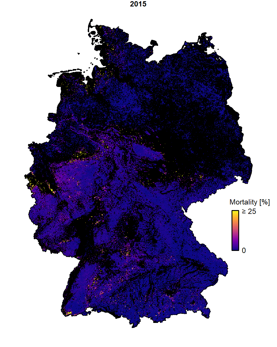
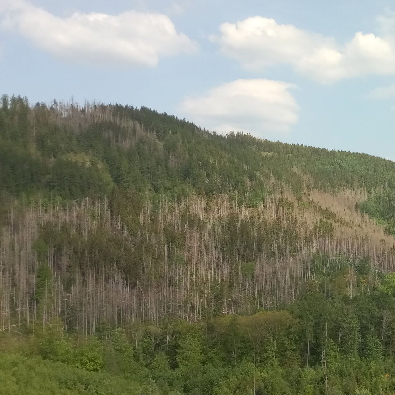
Most years in the period from 2018 to 2022 have been exceptionally dry in Central Europe. In Germany’s forests, this long-lasting drought has caused unprecedented tree mortality. Systematic ground-based surveys, such as the annual Crown Condition Survey, provide information on the vitality status of the different tree species and their mortality rates. However, models are needed to be able to map the spatial patterns of mortality for each tree species based on cause-effect relationships derived from field observations. In this study, logistic regression models were used to identify the most important drivers of mortality for the most important tree species in Germany. For this purpose, the dead and surviving trees from the Crown Condition Survey were combined with a large set of potential predictor variables from the domains of climate, topography, soil, land cover and deposition. After feature selection, the models were evaluated using the area under the curve (AUC) statistic. Norway spruce (Picea abies; AUC = 0.9) showed by far the greatest increase in mortality, with the country-wide average observed and predicted rates approaching almost 10% per year from 2020 to 2022, and much higher predicted rates at the regional level. Much of the spruce mortality was explained by the climatic water balance of the driest summer in previous years. The other main tree species also showed clear mortality responses to the drought conditions. However, in the case of European beech (Fagus sylvatica; AUC = 0.94) and Pedunculate and Sessile oak (Quercus robur and petraea; AUC = 0.88), the peaks in the time series of the country-wide mortality rates stayed below 1%. For these broadleaved species, mortality was more dependent on a range of site conditions, i.e., soil and topography. For Scots pine (Pinus sylvestris; AUC = 0.76), for which the observed mortality rate peaked at 1.2% in 2020, the given drivers could explain mortality only to a lesser degree than for the other species. The regression models were used for spatial prediction to produce country-wide maps of species-specific mortality rates at annual temporal and 100-m spatial resolution, covering all years from 1998 to 2022. The maps visualize the spatial patterns of mortality over time. The regions in western and central Germany, which were most seriously affected by spruce dieback can clearly be identified. The models and maps presented can be used for risk assessment, forest planning, and tree species selection, providing decision support for forest practitioners.
Link to the fulltext: https://doi.org/10.1016/j.foreco.2024.122081
Map data and models for download: https://zenodo.org/records/10805412
30.05.2024
Animation graphic of mortality rates of spruce
The animation graphic shows the mortality rates of spruce from 0 to over 25 percent over the years 2015 to 2022.