Dossier
Monitoring: National Soil Surveys in Forests and Agricultural Land
Nicole Wellbrock, Christopher Poeplau | 02.05.2022
Soils provide plants with nutrients and water, they are a habitat for a variety of organisms and affect our climate. Only those who know the condition of their soils can use them sustainably and protect their diverse functions. The status of soils in Germany is therefore regularly examined.

In a nationwide German approach, the Thünen Institute investigates agricultural and forest soils at more than 5,000 locations. The scientists take into account regional differences and small-scale characteristics of soils as well as the diversity of their use.
Soil processes take place slowly. Therefore, regularly recurring surveys are necessary to obtain meaningful results.
The first National Forest Soil Inventory was carried out for the first time from 1987 to 1993. The second inventory was conducted from 2006 to 2008. The third inventory began in March 2022 and is scheduled to be completed by the end of 2024.
Germany's agricultural soils were also surveyed for the first time from 2011 to 2018 with the National Soil Inventory in Agriculture. A repetition will take place from 2023 to 2027.
A key finding of these inventories: in Germany, the current organic carbon storage capacity of soil (0-90 cm) and vegetation in forests and agricultural land together is around 5 billion tons.
As part of the nationwide inventories of forest and agricultural soils, scientists look inside the soils: they determine the soil type, carbon content, structure and storage density of the soils, as well as many other parameters. They also investigate the processes that take place in the soil. In this way, knowledge about soil as a resource is constantly being expanded in a large number of individual investigations.
Inventory design of the forest soil survey
The nationwide forest soil survey is a federal/state cooperation. The respective federal states collect the data in the field and analyze samples in the laboratory according to uniform methods. The federal government has mandated the Thünen Institute with the coordination and nationwide evaluation. The systematic sampling network covers the entire forest area of Germany. About 1,900 inventory points were sampled in a grid of 8 by 8 kilometers.
Sampling is carried out at 8 satellites, each located at a distance of 10 meters from the mid-point. The distance corresponds to 45 degrees starting in north direction. The humus layer is sampled as well as different depth levels in the mineral soil (0-5, 5-10,10-30, 30-60 and 60-90 centimeters). All samples of one depth level are combined into composite samples.
At the inventory points, the participating teams of the federal states conducted a comprehensive soil profile approach. This was done on a soil profile – which is a vertical section from the surface through the soil – at the inventory point. Teams of experts determined more than 66 parameters on the soil profile and in the field, amongst otherssoil type, humus content, groundwater level and parent rock.
In addition to soil, other studies are conducted on nutritional status, ground vegetation, dead wood, and stocking. A sub-sample in a grid of 16 by 16 kilometers is part of the forest condition survey. A total of around 443 laboratory parameters were examined on more than 50,000 samples of humus, mineral soil, leafs and needles.
Inventory design of the agricultural soil survey
The first nationwide agricultural soil survey with focus on stocks of soil organic matter was conducted from 2011 to 2018 by the Thünen Institute of Climate-Smart Agriculture. In a grid of 8 by 8 kilometers, a total of 3,104 sampling points under arable land, grassland and special crops were investigated with the active support of the farmers.
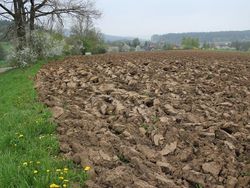
A profile pit of one cubic meter was excavated at each of the sampling points. In addition, eight soil cores were taken. The profile pits were precisely measured by GPS and additionally marked with a subsoil marker, allowing them to be precisely located for repeat samplings.
Soil mapping with recording of soil typological parameters and sampling was carried out by experienced soil scientists of the Thünen Institute. Soil samples were collected and analyzed from depth levels 0-10, 10-30, 30-50, 50-70, and 70-100 centimeters. A questionnaire provided information on the management of the last ten years.
In the years 2023 to 2027, the agricultural soil survey will now be repeated. The primary objective is to identify possible changes in the stocks of soil organic matter and their causes. Compared to the first inventory, there are some changes in the sampling scheme and the parameter list: In the future, four small profile pits will be opened around each initial soil profile and sampled at depths of 0-10, 10-30, and 30-50 centimeters. Soil properties below 50 centimeters will be considered stable at ten-year intervals and therefore will not be re-determined initially. Static soil properties such as texture and stone content will also not be re-determined. First interim results will be published at the end of 2025.


Publications National Forest Soil Inventory
Thünen Report 43
Dynamik und räumliche Muster forstlicher Standorte in Deutschland – Ergebnisse der Bodenzustandserhebung im Wald 2006 bis 2008 (558 p. German)
Status and Dynamics of Forests in Germany Results of the National Forest Monitoring
Publications National Soil Inventory in Agriculture
Thünen Report 64
Landwirtschaftlich genutzte Böden in Deutschland – Ergebnisse der Bodenzustandserhebung (248 p. German)