FAQ
Forest and floods
Kai Schwärzel, Tanja Sanders, Marco Natkin, Janis Kreiselmeier | 17.09.2024
Floods are a regular feature of riverine landscapes. Their occurrence depends on various factors: Precipitation, relief and subsoil, vegetation and soil management. Whether a flood occurs, however, is largely determined by how saturated the forest floor is with water.
During a flood, bodies of water such as rivers or lakes temporarily burst their banks. They inundate land that is not normally covered with water. Floods are caused by prolonged rain, short rain events with very large amounts of precipitation or snowmelt. We speak of floods when a river carries more than two to three times the annual average water level.
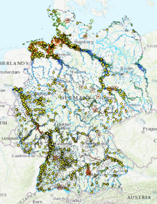
The Federal Institute of Hydrology (BfG) also provides up-to-date information on floods:
https://geoportal.bafg.de/karten/HWRM_Aktuell/
Firstly, the so-called runoff forms, i.e. the water that the soil can no longer absorb after heavy rainfall. Depending on the gradient of the slope and the nature of the surface, it runs off more slowly or more quickly.
This run-off water collects in streams and rivers. Depending on how quickly the runoff arrives there, a highly concentrated or flattened flood wave is created. The height of this wave depends on the flow velocity of the water. Such floods are favoured by straight and narrow river courses. Curved river courses with flat banks and rough ground slow down the flow velocity. The flood wave flattens out. Very heavy rainfall can trigger flash floods. They usually occur briefly and locally. In particular, the so-called five-B weather conditions (Vb weather conditions), low-pressure areas that move from the Gulf of Genoa, from northern Italy and from the northern Adriatic across the Alps to Central Europe, can cause very heavy precipitation over large areas. These then also lead to flooding of large rivers over several days, such as the Oder in 1997 and the Elbe in 2002, 2013 and 2024.
Wooded areas can reduce the course of a flood to a certain extent:
- Slower surface runoff: The dense forest vegetation and the underground network of root channels ensure that water seeps into the ground more quickly. This reduces the flow rate of water on the surface. This effect is particularly strong with deep-rooted tree species such as pine or oak.
- Interception of precipitation: Forests in moderately humid latitudes, such as in Europe and North America, retain between 15 and 50 per cent of the average precipitation in the treetops, undergrowth and litter layers over the long term. The rainwater adheres to the leaves and needles. It then evaporates without reaching the soil surface. More water is retained in coniferous forests than in bare deciduous forests. However, the relative impact of this effect is greatly reduced during heavy, flood-triggering precipitation events.

The deeper the so-called loose material above the solid rock, the more water a soil can store. Floods usually occur in mountainous terrain. Shallow, stony soils often prevail there. These factors cannot be changed by cultivation. This is why forest soils have very different capacities to store water. However, these storage capacities influence the course of floods. The more water a soil can store, the lower the surface runoff. In addition to this basic ability to store water, it also depends on previous precipitation.
The thickness and composition of the soil are essential for how much water a soil can store. The stored water is located in the cavities and interstitial spaces. When these are filled, further precipitation leads to an overload of the soil water reservoirs. The soil is then saturated with water. This increases surface runoff and the risk of flooding increases. Hydrological models have shown that a heavily forested catchment area can reduce an initial runoff peak by up to 70 per cent. However, this effect was hardly noticeable in a subsequent precipitation event.
Maintaining a covering layer of trees and shrubs in areas where floods occur improves water retention and erosion protection. The protective cover layer delays runoff and reduces the risk of landslides and mudflows. Digital information on local soil properties and landscape forms is used to identify critical nodal points for the development of floods. These include, for example, clear-cutting after bark beetle infestation or storm events.
These silvicultural measures are promising:
- Reforestation with site-appropriate tree species: Above all, structurally rich mixed stands in which branches and brushwood remain reduce and delay surface runoff.
- Renaturalisation: The renaturalisation of hillside moors, wetland biotopes, streams and floodplains supports water retention in areas where floods occur.
- Protection forest maintenance: The preservation of intact forests is achieved through preventive logging to rejuvenate and stabilise the stands and to maintain the young forest. Erosion control and the reduction of driftwood near bodies of water also contribute to a reduction in driftwood and sediment.
- Afforestation of agricultural soils: Afforestation of agricultural soils increases the capacity of the soil to store water. This delays and attenuates runoff peaks. In addition, afforestation on grassland and arable land along slopes can slow down surface runoff and reduce the erosion of the soil by runoff water. Strips of fast-growing species parallel to the slope are particularly suitable for this purpose.
- Adaptation of forest infrastructure: Runoff peaks in forested catchment areas are closely linked to the infrastructure required for forest management: the forest road network, side ditches, skid trails and drainage systems. These facilities are optimal flow paths that can accelerate runoff formation. To slow down flooding, paths and ditches should run under tree crowns. Path profiles should be adapted in such a way that they enable wide-area drainage into the neighbouring forest. Paths should not be laid in the direction of runoff.
- Improving the soil structure: How much water infiltrates into the soil depends largely on how the soil is managed. If the soil is heavily compacted, it is difficult for water to seep away. As a result, water collects on the soil surface and - if the area is sloping - flows downhill. For this reason, heavy machinery should not be used in the forest, especially in areas where floods occur. Instead, alternative timber harvesting and skidding techniques should be used. Liming acidified forest sites or converting coniferous stands into mixed stands also promotes soil biological activity and thus an improved soil structure.


